An open handbook titled 'The LifE Handbook' with sections showing rescue imagery and flood-risk environment illustrations.

LifE Project

Location: Hackbridge, Peterborough & Littlehampton

Client:
Defra, UK.

Team: BRE, Cyrill Sweett, Halcrow Group, Fulcrum Consulting, LDA Design.

Steering group:
Environment Agency, Homes England, University of Sheffield, AXA Insurance, and CABE.

Scope:
3 x community masterplans, each with minimum of 2000 news homes and associated assets. The innovation fund seeks to improve future delivery of flood and coastal erosion management, by providing innovative approaches to enable development in flood risk zones.

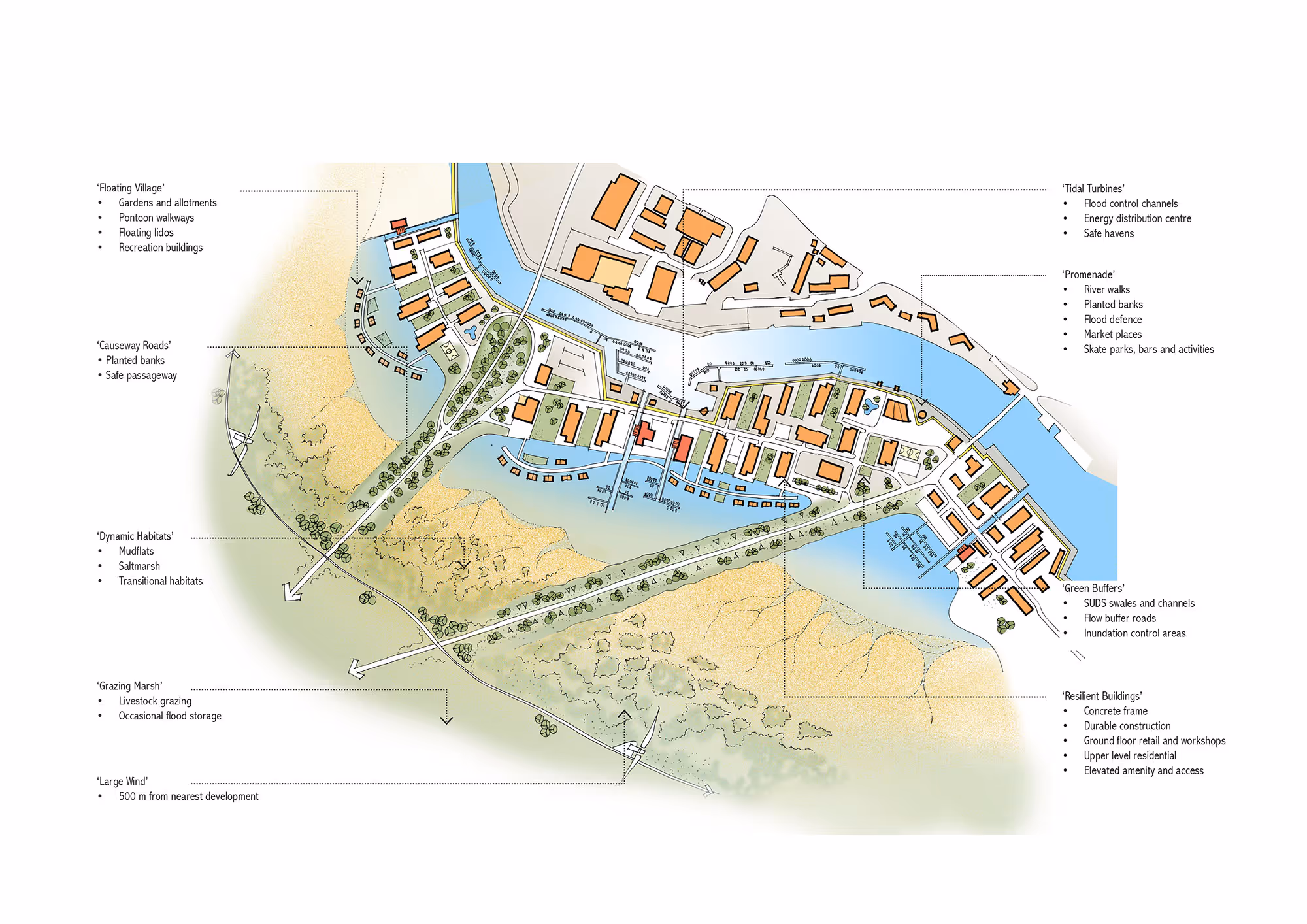
LifE: Long Term Initiatives for Flood-Risk Environments

The LifE Project (Long-term Initiatives for Flood-risk Environments) was developed by BACA architects as part of Defra’s Making Space for Water programme.

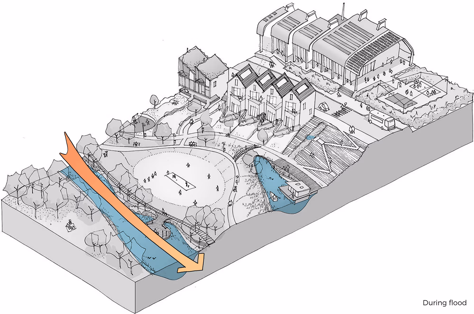
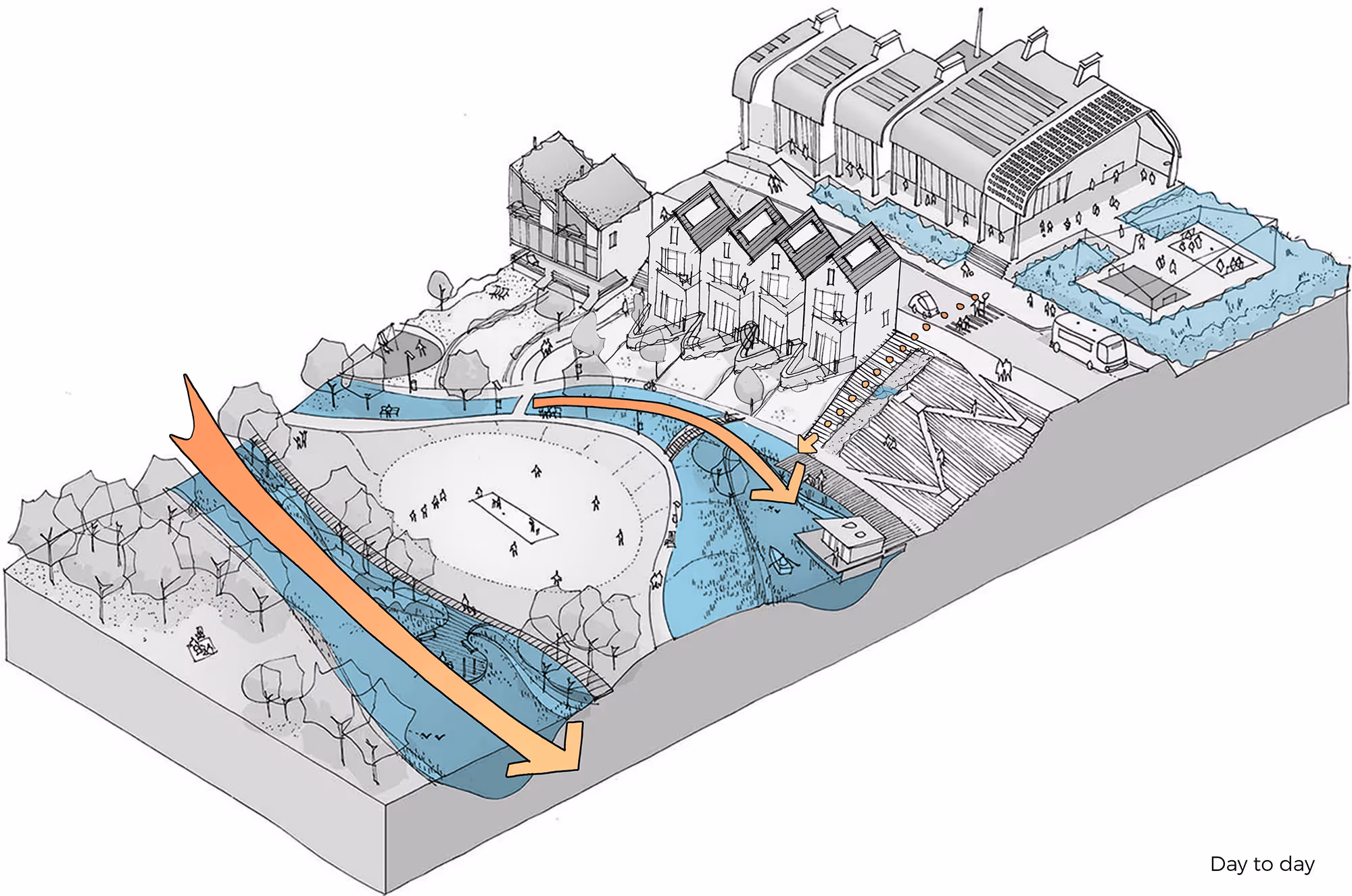
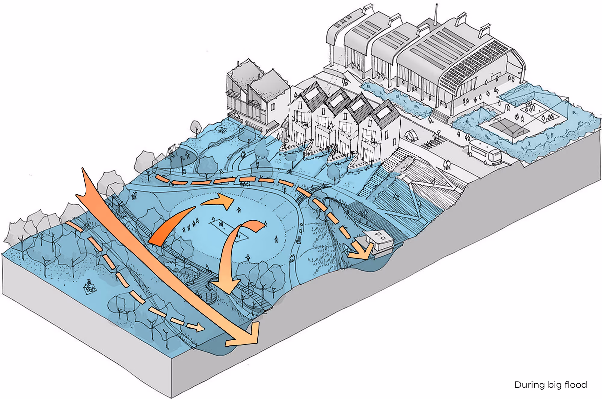
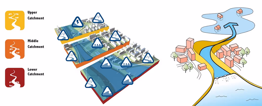
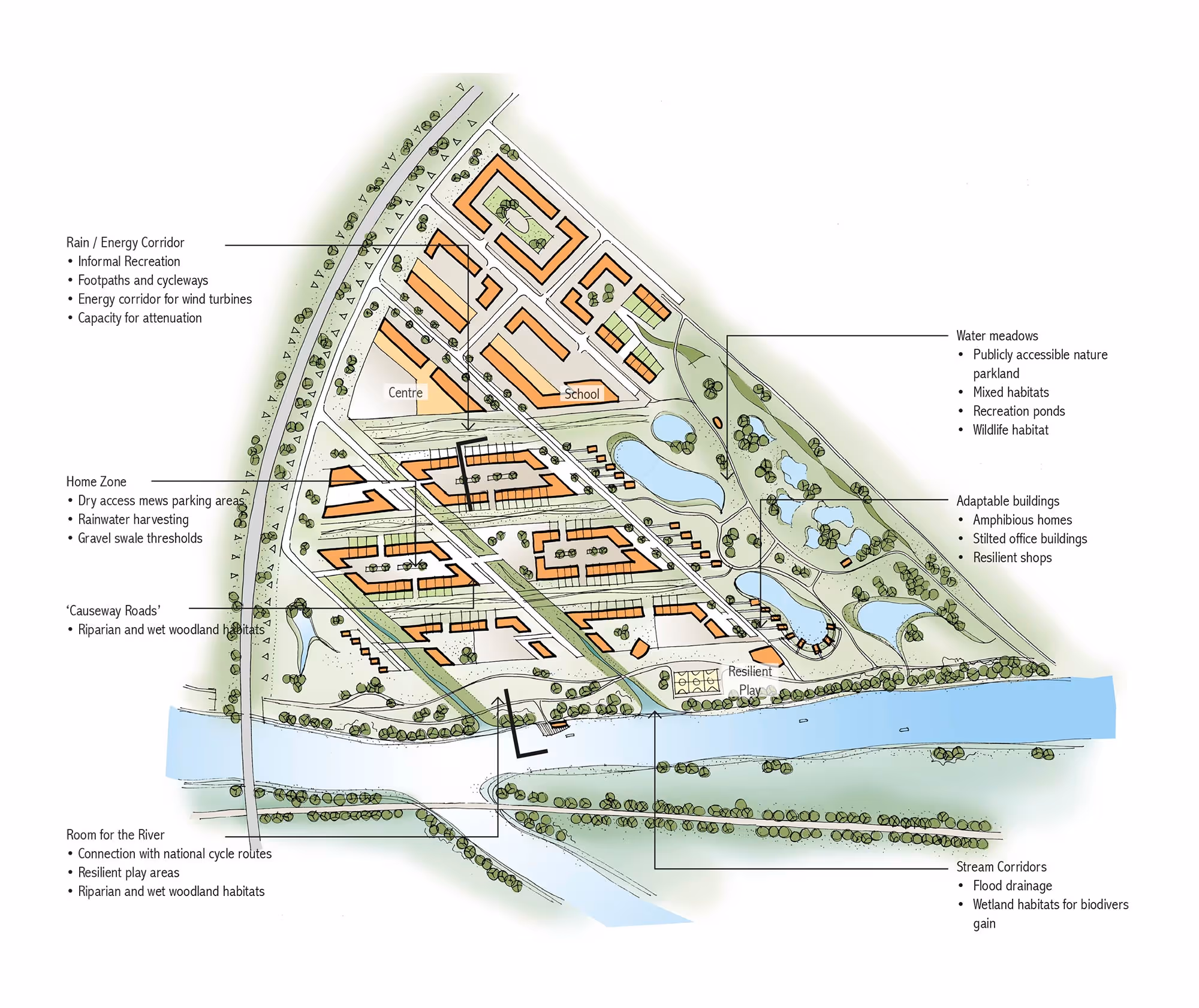
LifE is our holistic urban systems approach that integrates water-sensitive planning, adaptive infrastructure and zero-carbon development. It channels nature-based solutions to create resilient places that work with water, not against it.

The project promotes design where managing flood risk becomes an asset rather than a constraint, encouraging communities to view water as an opportunity to shape sustainable, liveable environments. The LifE approach provides a clear framework to unlock difficult flood risk sites for safe development.

Venn diagram with three overlapping circles labeled Increased Risk of Flooding, Development Pressure, and Environmental Changes, with intersections labeled Living with Water, Making Space for Water, Eco Design, and the center labeled LifE.
Cartoon showing a coastal barrier made of large bags with pound signs to prevent rising sea levels, marked with years 2010, 2020, and 2050, with a truck and crane handling money bags near a village.

Project Aims

The LifE project is one of six projects funded by Defra’s Flood and Coastal Erosion Risk Management – Innovation Fund and is part of Defra’s Making Space for Water programme.

The Innovation Fund seeks to improve future delivery of flood and coastal erosion risk management by promoting innovative approaches that contribute towards the development of more holistic and sustainable policymaking in the future.

The LifE framework reimagines how cities, neighbourhoods and buildings can respond to flood risk. By adopting a non-defensive approach (minimising the amount of hard engineered flood defences) LifE shifts from conventional flood prevention to creating space for water, allowing it to be stored, slowed and guided through predetermined routes with minimal disruption to everyday life.

These spaces often serve a dual purpose: play areas, public parks, or even energy-generating landscapes that function as community assets during dry periods. The process embeds engagement with local communities from the outset, ensuring that design proposals respond to social as well as environmental needs. This nature-based approach is low carbon, and have wider benefits of wellness, increased biodiversity and contributes to urban cooling.

Project Sites

The LifE research explored conceptual masterplans in Hackbridge, Peterborough, and Littlehampton, producing replicable strategies for flood-resilient development across the UK and internationally. Each side was charged with delivering a minimum of 2000 new homes, providing policy-compliant amenity and play space, and delivering a large portion of energy on site.

Each masterplan responded to its position within the watercourse, divided into upper, middle and lower flood catchments. Building uses were located according to their vulnerability, with housing stock located in the safest areas.

Where it was challenging to locate housing outside the floodplain, the guidance provided a range of architectural typologies, from traditional, elevated, amphibious and then floating homes. This toolkit would then enable the community to be adaptable to increased weather variations that it might face over the next century.

Elements of the research have since informed local planning policy and are being applied in live projects. Internationally,The LifE approach has been exported to Holland, and forms the foundation of Nijmegen’s ‘Room for the River’ project – a €365m flood relief channel and new park.

Group of people gathered around a table looking at a large architectural plan inside a room with high arched windows and columns.
Architectural illustration showing a neighborhood with houses, a park, and a waterway flooding, highlighted by a large orange arrow indicating floodwater flow.
Architectural illustration showing a residential and recreational area with water features and large orange arrows indicating stormwater flow through the site.
Architectural diagram showing a neighborhood flooded with water in blue, highlighting flood flow paths with large orange arrows during a big flood.
Diagram illustrating upper, middle, and lower catchment areas in a watershed with urban elements, symbols for water flow and treatment, and water moving through a city to a water body with houses nearby.
White abstract winding river inside a rounded yellow square.

Hackbridge

In Hackbridge, the River Wandle’s fast-responding flows create a risk of flash flooding that is expected to worsen with climate change. We proposed a central blue and green space that manages floodwater while creating a strong community focus.

Higher-density homes sit safely in low-risk areas near the station, while rain gardens, planted gullies and a landscaped floodable “village blue” slow and store water during storms. Regraded riverbanks create new habitats and extend the Wandle Trail for walking and cycling.

A flexible village green supports recreation, future flood storage and ground-source energy, while solar panels and biomass CHP form a local district energy system. The result is a neighbourhood shaped around water, resilience and high-quality public space.

Map of Hackbridge site showing Village Blue with wetland habitats, rain gardens, causeway for floodwater, Room for the River trail, water mills, school area, Village Centre with shared vehicle and pedestrian space, event space, community gardens, Village Green open space, and swale floodwater management features.
White abstract river flowing between geometric shapes on an orange square background with rounded corners.

Peterborough

Peterborough's flood risk comes from the River Nene and long durations of standing water. We explored ways to reconnect the city with the river by redeveloping brownfield and landfill sites, concentrating higher density development in low-risk areas near the centre.

At the Fengate landfill site, level changes allow new green corridors to guide floodwater safely away from homes, with permanent water bodies creating habitats and spaces for recreation.

The strategy integrates renewable energy through solar panels, wind turbines and biomass, supported by a SUDS network of green roofs, permeable surfaces and swales. Buildings in higher-risk zones are designed to be flood-resilient, forming adaptable neighbourhoods that can respond to a changing climate.

Site plan of a community layout showing labeled zones including a rain/energy corridor, home zone, causeway roads, water meadows, adaptable buildings, room for the river, and stream corridors with features like footpaths, cycleways, wildlife habitats, and resilient play areas.
White winding river icon over a dark red rounded square background.

Littlehampton

Littlehampton's largest threat is tidal flooding, with rising sea levels posing significant long-term risks. We developed a strategy that restores the historic floodplain and introduces tidal lagoons to manage storm water while creating diverse inter tidal habitats.

Excavated material raises the harbour site above future flood levels, allowing mixed-use development on safer land. Renewable energy systems, green roofs and rainwater harvesting reduce environmental impact and runoff, while a new Lagoon Promenade offers recreation and floating structures that bring activity to a resilient, climate-adapted waterfront.

Illustrated site plan of a coastal development including floating village, causeway roads, dynamic habitats, grazing marsh, tidal turbines, promenade, green buffers, and resilient buildings with annotations describing features and functions.

Book Launch

The LifE project was launched at London City Hall, the workplace of the Mayor of London at the time and attended by policy makers, planners, architects, engineers and many of London's municipalities.

Crowd gathered outside London City Hall with Tower Bridge visible across the River Thames.
Woman in red suit holding a microphone and speaking during a seated conference discussion with attentive participants around her.
Two men reading brochures or magazines at a business event, with other people in the background.
Group of young people standing and walking near a glass wall with blue water-themed graphics and red text promoting rainwater harvesting.
Business professionals in suits networking and viewing informational posters in a modern, sunlit conference space with large windows.
Business professional in a suit speaking at a podium to an audience seated in a modern conference room with large windows.
Large crowd seated on outdoor steps near a modern glass building with reflections and part of a bridge in the background.
Group of four people, two facing informational posters about Peterborough and Littlehampton catchment areas, in a modern indoor setting.
Three adults viewing informational display boards about Littlehampton, Peterborough, and coastal catchment projects.
Stack of six books on water-related topics, including aquatecture, floating architecture, water resource, urban flood risk management, and flood design.